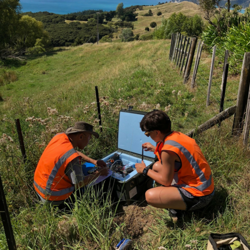
Scientists have completed the retrieval of 89 land-based sesimometer stations that have been installed in the Gisborne and Bay of Plenty regions during the last four months. Data from the instruments will help scientists better understand the geological structures where major earthquakes occur in these regions and the makeup of the rocks along the structures.
The seismometers are highly sensitive instruments that measure all sorts of vibration, such as shaking from an earthquake or even trucks driving past. The instruments have recorded both local earthquakes and larger global earthquakes since they were deployed (late last year).
They also recorded vibrations generated by the US research vessel Marcus Langseth. The ship produced sound energy offshore to help the scientists fill in gaps in regions where not many earthquakes occurred while the instruments were out. The data collected from the land-based seismometers will be used alongside the data recorded at sea from 100 ocean-floor seismometers deployed at the same time.
“All of the data acquired,’’ says Dr Stuart Henrys from GNS Science, “will help develop a subsurface image showing where different layers of rock meet, and will enable scientists to interpret the shape and frictional properties of the Hikurangi subduction zone.”
The Hikurangi subduction zone is where the Pacific Plate is sliding beneath the Australian Plate under the East Coast.
The seismometers were powered by a combination of batteries and solar panels. Some of the batteries were donated to the landowners by GNS Science and, in Ruatoria, the local Community Link Area Coordinator for Tairāwhiti Civil Defence and Emergency Management is now using their battery as a back up for their Civil Defence radio.
The installation of this unusually high number of seismographs across the district has been part of the Seismogenesis Hikurangi Integrated Research Experiment (SHIRE) research project.
The lead principal investigator from the US for the land deployment, Dr David Okaya of the University of Southern California says “The project involves a number of components to look for evidence of past earthquakes, and collecting geological and geophysical data that will be integrated with computer models with the aim of helping to understanding subduction earthquake behaviour.”
The SHIRE research project is one of several large-scale international research projects that will be focusing on the East Coast over the next few years. While each of these projects has different objectives, the major goal is to better understand the Hikurangi subduction zone which lies off the East Coast of the North Island.
Scientists hope that building a more detailed picture of the subduction zone will help to understand why slow-slip events occur in the region, and how these may affect the location of future large earthquakes.
The SHIRE research project is funded by the US National Science Foundation and involves scientists from University of Texas, California State Polytechnic University, University of Southern Mississippi, Pennsylvania State University, and University of Southern California.
The New Zealand involvement in the project is supported by the Ministry of Business Innovation and Employment (MBIE) Endeavour and funding to GNS Science, and also includes support from Victoria University of Wellington. The Ocean Bottom Seismographs come from the Japan Agency for Marine-Earth Science and Technology. In addition, SHIRE used instruments provided by IRIS Passcal (USA) and University of Tokyo. The Ocean Bottom Seismographs were deployed by NIWA’s deep-sea research ship RV Tangaroa with funds provided by MBIE.
Disclaimers and Copyright
While every endeavour has been taken by the East Coast Lab Hikurangi Subduction Zone M9 to ensure that the information on this website is
accurate and up to date, East Coast Lab Hikurangi Subduction Zone M9 shall not be liable for any loss suffered through the use, directly or indirectly, of information on this website. Information contained has been assembled in good faith.
Some of the information available in this site is from the New Zealand Public domain and supplied by relevant
government agencies. East Coast Lab Hikurangi Subduction Zone M9 cannot accept any liability for its accuracy or content.
Portions of the information and material on this site, including data, pages, documents, online
graphics and images are protected by copyright, unless specifically notified to the contrary. Externally sourced
information or material is copyright to the respective provider.
© East Coast Lab Hikurangi Subduction Zone M9 - www.eastcoastlab.org.nz / +64 6 835 9200 / info@eastcoastlab.org.nz
