Hawke’s Bay is known for its beautiful, sunny beaches and easily accessible coastline. This draws many people to the area, however it comes with some downsides. The many homes and buildings sitting right next to the sea are highly vulnerable to natural hazards like tsunamis and sea-level rise.
This is why on the 27th of February 2018 a group of year 13 classes from Napier Girls’ High School had a classroom session on coastal hazards, coastal hazard management and how to measure coastal processes.
The young women started their day by learning about coastal hazards and risk and how these risks will change with climate change and sea-level rise in the coming century from a coastal scientist at the University of Auckland. Various coastal adaptation options were also discussed, along with the importance of community engagement in coastal issues.
The sudetns also met with a panel of local coastal stakeholders to ask them questions about past, present and future coastal management in the region. The stakeholders included a local government asset manager, a local councillor, and a local community board member, as well as Resilience Challenge ‘Edge’ researcher Emma Ryan from the University of Auckland.
Following the panel session, the students learned more about the dynamics of, causes of and ways to measure coastal erosion.
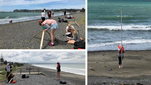
Two days later the students were able to put their new skills to the test and headed out into the field to get their hands dirty. A researcher from The University of Auckland accompanied the group on their field trip to Waimarama and Westshore beaches in Hawke’s Bay.
The students put to practice the skills they learned in the classroom session, measuring beach profiles to explore beach change over time, measuring wave and currents and measuring sediment size and texture.
This exercise was part of a citizen science project that the Resilience Challenge’s Living on the Edge Co-Creation Laboratory have developed together with East Coast LAB (Life at the Boundary) and teachers at Napier Girls’ High School.
This is the second time this activity has been carried out, with a classroom of students taking part in the same programme last year. The intention is that the students will build up a coastal dataset over the years if this project continues. This dataset could be used to monitor beach change over time. In any case, the citizen science project is a useful way to get students interested and actively involved in their local coastline and coastal management.
For more information go to the Resilience to Nature's Challenges website.
Disclaimers and Copyright
While every endeavour has been taken by the East Coast Lab Hikurangi Subduction Zone M9 to ensure that the information on this website is
accurate and up to date, East Coast Lab Hikurangi Subduction Zone M9 shall not be liable for any loss suffered through the use, directly or indirectly, of information on this website. Information contained has been assembled in good faith.
Some of the information available in this site is from the New Zealand Public domain and supplied by relevant
government agencies. East Coast Lab Hikurangi Subduction Zone M9 cannot accept any liability for its accuracy or content.
Portions of the information and material on this site, including data, pages, documents, online
graphics and images are protected by copyright, unless specifically notified to the contrary. Externally sourced
information or material is copyright to the respective provider.
© East Coast Lab Hikurangi Subduction Zone M9 - www.eastcoastlab.org.nz / +64 6 835 9200 / info@eastcoastlab.org.nz
