Scientists are preparing for New Zealand’s largest ever deployment of seafloor earthquake recording instruments in a bid to learn more about the earthquake behaviour of the tectonic plates beneath the East Coast of the North Island.
The seismometers will record earthquakes and slow-slip events that occur in an area known as the Hikurangi subduction zone which marks the boundary of the Pacific and Australian tectonic plates.
It is arguably New Zealand’s most significant active fault and is capable of generating a magnitude 8.5 earthquake that, in addition to widespread ground shaking, is also likely to produce a tsunami, coastal uplift and subsidence, landslides and liquefaction.
Involving scientists from New Zealand, Japan, the US, and the UK, the large-scale collaborative project is aimed at better understanding the potential threat to New Zealand from the Hikurangi subduction zone.
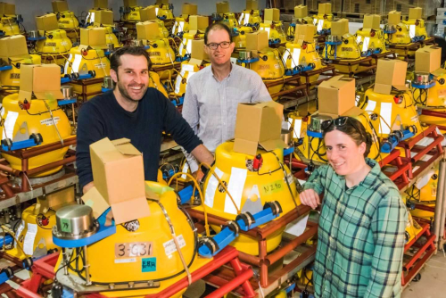
It will kick off in late October when NIWA’s research ship Tangaroa will lower 100 specially made seismometers, known as Ocean Bottom Seismometers and on loan from Japan, onto the seafloor in a grid pattern running from offshore Wairarapa north to east of Ruatoria.
In addition to the seafloor instruments, scientists will deploy more than 200 land-based seismic instruments across the Raukumara Peninsula.
The seafloor and land-based instruments will record echoes from within the Earth from both naturally occurring earthquakes and from acoustic signals generated by a US research ship, Marcus Langseth, which will bepositioned off the East Coast. This will enable scientists to create images of the plate boundary fault zone both underneath the sea and beneath the land.
The cat scan-like images will show the structure of the Earth’s crust down to a depth of about 30km.
In most places over the study area the images will be two-dimensional, or like slices through the Earth. However, a more intensive survey area northeast of Gisborne will produce three-dimensional images of the plate boundary collision zone.
The images will show the position of the two tectonic plates and also help scientists determine the physical properties of the various rock layers that make up the subduction zone.
The nature of the rock material on the grinding surface of each plate affects how the two plates move past each other.
Using this information, scientists can learn more about how the plates are locked together at numerous points along the subduction zone.
New Zealand project leader Dr Stuart Henrys, of GNS Science, said the data will help the understanding of why different areas of the plate boundary are behaving so differently.
Some parts of the plate interface slide past each other every year or so in events called slow earthquakes, while other parts appear to be stuck fast and are storing energy for a future large earthquake.
Lead US investigator from the University of Texas, Harm Van Avendonk, said the project would produce detailed images of the entire fault system across this part of the North Island.
“A better understanding of what causes the marked differences in tectonic behaviour on this plate boundary will help New Zealand government agencies in their efforts to reduce the danger posed by earthquakes and tsunami in this area,” Dr Van Avendonk said.
“What makes subduction zones rupture in huge, tsunami-generating earthquakes is one of the most pressing questions facing Earth scientists today.”
Dr Henrys said the more intensive study zone northeast of Gisborne was an exciting prospect as it should provide the best images yet, anywhere in the world, of the zone where slow-motion earthquakes are known to occur repeatedly.
Scientists regard the area off the East Coast as the best place in the world to study and understand the phenomenon of slow-motion earthquakes. This is because it is more accessible and shallower than other subduction zones around the world, which are typically further from shore.
Dr Henrys added that the marine seismic reflection system being used in this project involved releasing compressed air quickly into the water with sensors towed behind the ship picking up ‘echoes’ from different rock types in the upper layers of the Earth’s crust.
Disclaimers and Copyright
While every endeavour has been taken by the East Coast Lab Hikurangi Subduction Zone M9 to ensure that the information on this website is
accurate and up to date, East Coast Lab Hikurangi Subduction Zone M9 shall not be liable for any loss suffered through the use, directly or indirectly, of information on this website. Information contained has been assembled in good faith.
Some of the information available in this site is from the New Zealand Public domain and supplied by relevant
government agencies. East Coast Lab Hikurangi Subduction Zone M9 cannot accept any liability for its accuracy or content.
Portions of the information and material on this site, including data, pages, documents, online
graphics and images are protected by copyright, unless specifically notified to the contrary. Externally sourced
information or material is copyright to the respective provider.
© East Coast Lab Hikurangi Subduction Zone M9 - www.eastcoastlab.org.nz / +64 6 835 9200 / info@eastcoastlab.org.nz
