RV Tangaroa Blog – Day 4 and 5: Re-route to Re-survey
Taylor Tracey Kyryliuk
On day 4, we realised that we need to resurvey some of the ocean-bottom seismometers (OBS) locations for the triangulation. During some of our measurements, either the Tangaroa or the instrument drifted farther than we were expecting from our initial coordinates – probably because of strong currents off the east coast.
When we do a survey, we drop the dunker into the water, but the communication between the dunker and the OBS isn’t instant. It takes some time to connect with the OBS. The OBS are all the way on the ocean floor, over 1000 m down! As a result, the Tangaroa may have drifted quite a lot before the dunker receives the signal of the Aquarius OBS. If that’s the case, we end up with survey points for our triangulation that don’t work effectively.
We saw this issue for about six of the twenty OBS we deployed. Fortunately, we’ve been making such good progress that we have some spare time to go and add in these extra measurements, and make sure our locations are really accurate.
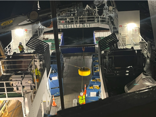
Between deploying the OBSs, we also need to get them out of their shipping containers. The Aquarius OBS is very heavy (~360kg). This requires the use of the crane on the boat. In order to have the least amount of rocking on the boat from waves, the Tangaroa just drifts while the crane operation is in progress.
While we wait for the OBS to sink to the bottom (which can take up to 70 minutes), or for the Tangaroa to transit between survey point locations, we can pass the time on the bridge by chilling to the music being played by the current crewmate that is steering the boat, reading or just observe the waves.

Personally, I found observing the waves to be a bit meditative and the best way for me to avoid seasickness.
By day 5, all the OBS were deployed! Now we are heading back to re-survey the OBS that needed to be re-triangulated. There’s a lot more waiting around on this day. Most of it is spent travelling to the next location. We write down the coordinates, describe the weather and then move onto the next spot.
To pass the time, because some stations are around 3 hours away from each other on the re-survey route, we sometimes hang out in the lounge and watch a movie from the Tangaroa’s large DVD collection. Or we watch members of the crew play darts in the mess.
The cruise has been super productive! If everything goes smoothly overnight, we will have finished a day early.
21 December 2023
Disclaimers and Copyright
While every endeavour has been taken by the East Coast Lab Hikurangi Subduction Zone M9 to ensure that the information on this website is
accurate and up to date, East Coast Lab Hikurangi Subduction Zone M9 shall not be liable for any loss suffered through the use, directly or indirectly, of information on this website. Information contained has been assembled in good faith.
Some of the information available in this site is from the New Zealand Public domain and supplied by relevant
government agencies. East Coast Lab Hikurangi Subduction Zone M9 cannot accept any liability for its accuracy or content.
Portions of the information and material on this site, including data, pages, documents, online
graphics and images are protected by copyright, unless specifically notified to the contrary. Externally sourced
information or material is copyright to the respective provider.
© East Coast Lab Hikurangi Subduction Zone M9 - www.eastcoastlab.org.nz / +64 6 835 9200 / info@eastcoastlab.org.nz
