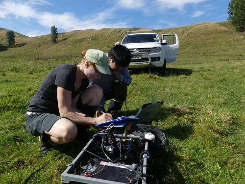
Scientists from GNS Science and Tokyo Institute of Technology will be installing instruments that measure the Earth’s natural magnet and electrical fields at sites across Gisborne over the next three weeks to better understand the Hikurangi subduction zone.
The instruments will measure the Earth’s very small natural magnetic and electrical fields at the surface and the measurements will be used to create a three-dimensional image of the Hikurangi subduction zone.
The Hikurangi subduction zone, off the east coast of the North Island, is where the Pacific tectonic plate is subducting beneath the Australian tectonic plate. The boundary between the two plates lies at a depth of 10-30km beneath the Raukumara Peninsula.
Scientists believe the Pacific tectonic plate is creeping slowly beneath the Australian plate in the north and appears to be stuck -or locked- in the south, potentially storing energy to be released in future large earthquakes.
“The instruments we are installing are made up of four small electrodes and three magnetic sensors that will be buried just beneath the ground. These are connected to a recorder by thin wires that sit on the surface,” says Project Leader Wiebke Heise of GNS Science.
“After two days of recording, we will remove all the equipment from each site and back fill all the small holes to make sure we leave very little sign that the instruments were ever installed.”
The instruments will be installed in 54 sites in late February and early March across the Gisborne region with some locations only accessible by helicopter.
“This research would not occur without the support of tangata whenua and private landowners who have given us permission to install the instruments on their land.”
The data collected will help to refine where the Hikurangi subduction zone is moving or stuck to improve the understanding of the earthquake and tsunami risk to the entire east coast of the North Island.
Disclaimers and Copyright
While every endeavour has been taken by the East Coast Lab Hikurangi Subduction Zone M9 to ensure that the information on this website is
accurate and up to date, East Coast Lab Hikurangi Subduction Zone M9 shall not be liable for any loss suffered through the use, directly or indirectly, of information on this website. Information contained has been assembled in good faith.
Some of the information available in this site is from the New Zealand Public domain and supplied by relevant
government agencies. East Coast Lab Hikurangi Subduction Zone M9 cannot accept any liability for its accuracy or content.
Portions of the information and material on this site, including data, pages, documents, online
graphics and images are protected by copyright, unless specifically notified to the contrary. Externally sourced
information or material is copyright to the respective provider.
© East Coast Lab Hikurangi Subduction Zone M9 - www.eastcoastlab.org.nz / +64 6 835 9200 / info@eastcoastlab.org.nz
