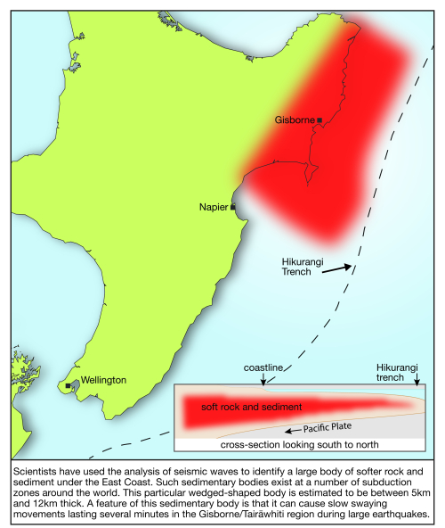
Analysis of seismic waves from the 2016 Kaikōura earthquake has enabled scientists to identify a body of softer rock and sediment roughly 37 times the volume of Mount Everest under the seafloor on the East Coast.
The wedge-shaped body is estimated to be between 5km and 12km thick and a key feature is that it can cause slow swaying movements lasting several minutes in the Tairāwhiti/Gisborne region during large earthquakes.
A study published this week in the Journal of Geophysical Research – Solid Earth and led by seismologist Yoshi Kaneko of GNS Science, says the sediment body measures about 300km long by 150km wide and it is probably the largest such body under the North Island.
Scientists already knew that softer rocks were present at the Hikurangi subduction zone, but this is the first time they have been able to estimate the approximate size and shape of the body.
Large bodies of sedimentary rocks occur at a number of subduction zones around the world. With the increasing use of networks of seismic instruments on the seafloor in many countries, scientists anticipate they will gradually find out more about the properties of these bodies.
During the Kaikōura earthquake, the sediment body resulted in slow swaying motions in the Tairāwhiti/Gisborne region lasting up to eight minutes.
Dr Kaneko said the swaying may not have been felt by people in the East Coast region as their senses would have been pre-occupied by the shorter more violent shaking of the quake.
“However, the swaying motion was recorded by both on-shore and offshore seismic instruments,” he said.
“It’s a bit like a bowl of jelly. When you jiggle the bowl a bit, the jelly moves even more. In this case, the stiffer ‘bowl’ is the Pacific Plate subducting under the North Island and the sediment wedge is above the plate.
“We were curious about the unusual behaviour of seismic waves from the Kaikōura earthquake in this region and that prompted us to try and identify the cause.”
As ‘long-period’ seismic waves travelled north through the Earth, they slowed down dramatically and started reverberating off Hawke’s Bay north of Napier.
“Based on the way the seismic waves behaved, we were able to model the body of softer rock and sediment.”
Dr Kaneko said it meant the region was susceptible to long, slow swaying during large earthquakes – perhaps even from earthquakes as far away as the Kermadec region. He added that the slow swaying effect only becomes pronounced in large earthquakes – those above magnitude 7.
Disclaimers and Copyright
While every endeavour has been taken by the East Coast Lab Hikurangi Subduction Zone M9 to ensure that the information on this website is
accurate and up to date, East Coast Lab Hikurangi Subduction Zone M9 shall not be liable for any loss suffered through the use, directly or indirectly, of information on this website. Information contained has been assembled in good faith.
Some of the information available in this site is from the New Zealand Public domain and supplied by relevant
government agencies. East Coast Lab Hikurangi Subduction Zone M9 cannot accept any liability for its accuracy or content.
Portions of the information and material on this site, including data, pages, documents, online
graphics and images are protected by copyright, unless specifically notified to the contrary. Externally sourced
information or material is copyright to the respective provider.
© East Coast Lab Hikurangi Subduction Zone M9 - www.eastcoastlab.org.nz / +64 6 835 9200 / info@eastcoastlab.org.nz
