Planning for a rupture of New Zealand’s largest fault - the Hikurangi subduction zone - has kicked into motion, with scientists certain it’s a case of when, not if.
Using a credible magnitude 8.9 earthquake and tsunami scenario, five Civil Defence Emergency Management (CDEM) Groups from across the North Island East Coast are working together to develop an emergency response plan that has communities at its heart.
Led by East Coast Life at the Boundary (LAB), the Hikurangi Response Plan will outline how to respond to a Hikurangi subduction zone earthquake and tsunami, and how to enhance communities’ preparedness for such an event.
Project Lead, Natasha Goldring, said building the collaborative response plan was vital in lifting readiness for, and resilience to a future earthquake and tsunami on the Hikurangi fault.
“The scenario we are using to support the development of this response plan is a very realistic example of what we could face in our lifetime, or that of our children and grandchildren,” Ms Goldring said.
She said although the project is being driven by CDEM groups, people still needed to make sure they understood the risks they face and take the necessary steps to prepare themselves. Information on how to prepare for an earthquake or tsunami can be found at www.happens.nz.
“Communities are at the centre of all response planning, and we want this project to be a collaborative effort. We are all responsible for ourselves and our families – we are all part of Civil Defence in New Zealand.”
The launch of the project comes in response to research over the last several years which is suggesting the likelihood of a rupture may be higher than initially understood.
GNS Scientist, Dr Laura Wallace, attributes this to a combination of factors, including new insights gained following the Kaikoura earthquakes, evidence for pressure building on the fault, and geological evidence for prehistoric earthquakes on the subduction zone.
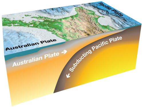
“A subduction zone is where one tectonic plate subducts (dives) underneath another—the boundary between these two plates forms a large fault. This one in particular runs offshore from the east of Gisborne down to the top of the South Island and poses a significant earthquake and tsunami risk to the entire east coast of New Zealand.”
She said subduction zone faults had been responsible for most of the world’s deadliest earthquakes and tsunamis to date, with Japan 2011 being the most recent example.
“We know the Hikurangi subduction zone can produce large earthquakes and tsunamis, and these events have happened in the past.
“While we’re carrying out more research to build a clearer picture of the hazard posed by the Hikurangi fault, we know a rupture at some point in the future is certain.”
A three-year project, the initial response plan will be developed in the project’s first year, to support the five CDEM Groups whom would be most affected on the North Island East Coast - Tairāwhiti (Gisborne), Bay of Plenty, Hawke’s Bay, Manawatu-Wanganui and Wellington (including the Wairarapa).
A series of planning workshops scheduled for February 2019 will engage the many stakeholders involved in the process, including CDEM, local and central government, infrastructure providers, emergency services, hospital and health providers, non-government organisations, experts from various universities and key business sectors.
The Hikurangi Response Plan is supported by the Ministry of Civil Defence and Emergency Management’s Resilience Fund.
[YouTube id=lH_PAGimWJM]
Disclaimers and Copyright
While every endeavour has been taken by the East Coast Lab Hikurangi Subduction Zone M9 to ensure that the information on this website is
accurate and up to date, East Coast Lab Hikurangi Subduction Zone M9 shall not be liable for any loss suffered through the use, directly or indirectly, of information on this website. Information contained has been assembled in good faith.
Some of the information available in this site is from the New Zealand Public domain and supplied by relevant
government agencies. East Coast Lab Hikurangi Subduction Zone M9 cannot accept any liability for its accuracy or content.
Portions of the information and material on this site, including data, pages, documents, online
graphics and images are protected by copyright, unless specifically notified to the contrary. Externally sourced
information or material is copyright to the respective provider.
© East Coast Lab Hikurangi Subduction Zone M9 - www.eastcoastlab.org.nz / +64 6 835 9200 / info@eastcoastlab.org.nz
