Children and disasters
Children pose an interesting challenge when it comes to Disaster Risk Reduction (DRR). They are vulnerable, so we instinctively want to protect them and not involve them in DRR. However, children also own valuable knowledge about hazards such as floods or earthquakes in their local area. They are also cognizant of vulnerable members of the community such as the elderly or those with disabilities, and of local capacities like emergency services and resources within their community. These are all key elements of Disaster Risk Reduction (DRR). Children can conduct risk assessments and have the legitimacy to participate in DRR activities, but they tend to be seen as weak and passive. As a result, they are often excluded from DRR initiatives. Furthermore, a challenge lies in making children’s knowledge tangible, usable and communicable to outside stakeholders such as government agencies, scientists and non-government organizations so dialogue can take place. This is important as generating discussion is essential to achieve DRR and build resilience at the local level.
One way that we may be able to overcome these obstacles is by taking advantage of recent advances in technology, with portable devices such as GPS, mobile phones, digital cameras, tablets, video games, and drones. Together with play, these technological innovations have the potential to better allow children to participate in DRR initiatives, while posing different challenges.
Researchers in our Resilience to Nature’s Challenges Cultural Resilience team have been assessing the role and contribution of technology and play in fostering the participation of children in DRR. The work pioneers two initiatives, including participatory mapping using Minecraft and LEGO modelling. The research project links researchers from Auckland University of Technology and The University of Auckland and practitioners from Hawke’s Bay region with CDEM groups and East Coast Lab as well as end users including Maraekakaho school and the wider community.
The potential of Minecraft and LEGO for building resilience
LEGO modeling and Minecraft provide opportunities to conduct participatory mapping, which is the collection, plotting and analysis of georeferenced data such as natural hazards, vulnerability and capacities in facing hazards. Children are very familiar with both LEGO and Minecraft since these games are grounded in their daily life. They potentially provide a platform for dialogue with practitioners and policy makers involved in DRR.
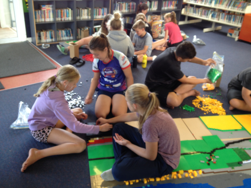
The project is done in partnership with the Maraekakaho school in the Hawke’s Bay region. LEGO and Minecraft were included in the school curriculum over one semester, which included two weekly sessions over an eight-week period. LEGO mapping was conducted with 13 children aged 10-12 years.
Children used 30,000 pieces of LEGO and came up with a 190cm x 114cm map which represented 3.12km x 1.92km of Maraekakaho. Participatory mapping using Minecraft involved 16 children aged 8-10 years.
Geographic information system (GIS) data was inserted into Minecraft, so children could map their school and the surrounding area. Check out the Minecraft version of Maraekakaho here.
For both Minecraft and LEGO, children identified the legend (i.e. hazards, vulnerability, capacities, land use type etc.) of their map, had to think about what constitutes a community, decided what could and could not be mapped, and reflected upon past events and their own knowledge about disasters and risk reduction.
This participatory process involved discussions, critical thinking and consensus building to map relevant information. Some of the positive outcomes and limitations associated with this process are summarized in the table below.
Strengths and weaknesses of LEGO and Minecraft to foster participation for DRR
| Strengths / positive outcomes | Weaknesses / challenges |
|
|
Both LEGO and Minecraft worked very well in fostering participation with children taking ownership of the process. This is because children are very familiar with both tools, and activities were fun rather than tedious. Produced maps are powerful tools for planning and carrying out DRR activities since they enable dialogue between children and external stakeholders. On the other hand, we also faced some difficulties related to the cost of buying and implementing the tools. Minecraft presented different technical challenges such as reliance on the Internet and Microsoft server, which can affect the entire process, while building a map at scale with LEGO is time consuming.
Ways forward
The team is currently working with the local stakeholders (schools and practitioners) on the different opportunities that LEGO and Minecraft provide to increase children’s participation in DRR. These include photogrammetry (see an example here), inserting scenarios (i.e. earthquake, tsunami, flood and climate change models) within Minecraft and LEGO modelling, and use of these tools in the long term, as well as scaling up in other schools.
Disclaimers and Copyright
While every endeavour has been taken by the East Coast Lab Hikurangi Subduction Zone M9 to ensure that the information on this website is
accurate and up to date, East Coast Lab Hikurangi Subduction Zone M9 shall not be liable for any loss suffered through the use, directly or indirectly, of information on this website. Information contained has been assembled in good faith.
Some of the information available in this site is from the New Zealand Public domain and supplied by relevant
government agencies. East Coast Lab Hikurangi Subduction Zone M9 cannot accept any liability for its accuracy or content.
Portions of the information and material on this site, including data, pages, documents, online
graphics and images are protected by copyright, unless specifically notified to the contrary. Externally sourced
information or material is copyright to the respective provider.
© East Coast Lab Hikurangi Subduction Zone M9 - www.eastcoastlab.org.nz / +64 6 835 9200 / info@eastcoastlab.org.nz
