Scientists have asked for public help in finding three ocean bottom seismometers, on loan from Japan, that failed to surface when they tried to pick them up from the seafloor two months ago.
The three instruments that have been recording seismic waves from earthquakes and other sources did not respond when scientists sent an acoustic signal to them from a ship during the recovery voyage in March.
Of the 100 that were deployed on the seafloor east of Gisborne late last year, 97 were successfully recovered. The instruments have been used to collect a CAT-scan-like image of the tectonic plates deep under the East Coast.
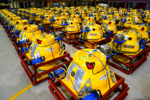
The bright yellow spherical instruments, about the size of a large beach ball, might float to the surface of their own accord and wash up anywhere along the Tairawhiti Coast. They carry the markings, GNS Science (NZ) plus some Japanese characters.
“The instruments are valuable and we would like to return them to our Japanese colleagues who kindly loaned them to us for the duration of the project,” said leader of the New Zealand team Stuart Henrys, a geophysicist at GNS Science.
The scientists ask anyone finding an unusual piece of equipment such as this to contact GNS Science at 04-570-1444. GNS Science will organise collection and cover the cost freight.
The international project that will continue until October, has involved the deployment of several hundred onshore and offshore seismic instruments to record seismic waves from earthquakes and from ships that generate pulses of sound directed at the seafloor.
The data collected by the onshore and offshore instruments is combined and helps scientists create a 3D image of the subduction zone down to a depth of about 15km below the surface.
“This gives scientists an insight into the properties of the rocks on either side of the plate boundary,” Dr Henrys said.
The Hikurangi plate boundary, a huge geological feature below the seafloor east of Gisborne, is where the Pacific tectonic plate dives beneath the Australian plate.
Dr Henrys said the focus of the research project will help to understand how, why, and how often the Hikurangi plate boundary fault moves in large earthquakes.
“The Gisborne region is an ideal natural laboratory to study how plate boundary faults behave,” he said.
Rebecca Bell, a geophysicist at Imperial College London and lead UK scientist on the project, said the dense deployment of seismographs on land and on the seafloor was a world first for the science community and provided an opportunity to develop images of unprecedented quality and resolution.
Dr Bell said most of the 200 land-based instruments had been recovered, but 50 seismographs would remain in place until October to record additional earthquakes.
“The 3D imaging project is embedded in even larger East Coast-wide seismic project of the Hikurangi margin, that has been ongoing over the summer and will enter a second phase early in 2019,” Dr Henrys said
He has issued a photo showing what one of the missing instruments looks like.
“We would love to hear from anyone if they find one of these Ocean Bottom Seismometers washed up on the shore.”
The 3D research project is funded by the National Science Foundation in the United States and the Natural Environment Research Council in Britain.
The New Zealand involvement in the project is supported by the Ministry of Business Innovation and Employment (MBIE) Endeavour Fund and funding from GNS Science. The Ocean Bottom Seismographs come from Japanese marine science agency JAMSTEC.
NZ3D used land instruments provided by Seis-UK, Geophysical Instrument Pool Potsdam, and University of Tokyo. The deployment of Ocean Bottom Seismographs was from the NIWA vessel RV Tangaroa with funds provided by MBIE
Disclaimers and Copyright
While every endeavour has been taken by the East Coast Lab Hikurangi Subduction Zone M9 to ensure that the information on this website is
accurate and up to date, East Coast Lab Hikurangi Subduction Zone M9 shall not be liable for any loss suffered through the use, directly or indirectly, of information on this website. Information contained has been assembled in good faith.
Some of the information available in this site is from the New Zealand Public domain and supplied by relevant
government agencies. East Coast Lab Hikurangi Subduction Zone M9 cannot accept any liability for its accuracy or content.
Portions of the information and material on this site, including data, pages, documents, online
graphics and images are protected by copyright, unless specifically notified to the contrary. Externally sourced
information or material is copyright to the respective provider.
© East Coast Lab Hikurangi Subduction Zone M9 - www.eastcoastlab.org.nz / +64 6 835 9200 / info@eastcoastlab.org.nz
