GNS Science, MetService and the Earthquake Commission (EQC) have joined forces to enhance real-time forecasting models for volcanic ashfall to help New Zealand communities manage future eruptions.
The ground-breaking EQC-funded project by leading GNS Science and MetService scientists will combine existing eruption scenarios with weather forecasting to better predict the likelihood of an area being affected by volcanic ashfall.
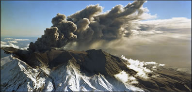
“New Zealand is dotted with active volcanoes and an eruption could impact communities far beyond the regions closest to the volcano,” says GNS Science volcanologist Dr Yannik Behr.
The project team are developing new forecasting models that in the near future will be able to provide more accurate estimates of how much ash will land, but also when it is likely to arrive.
“Power companies need to know the risk of flashovers due to ash, NZTA needs to know if the markings on the roads will become invisible and dairy farmers will be interested how much ash their cows may be ingesting from the grass,” says Dr Behr.
The Taupo-based scientist says in previous eruptions GNS Science would traditionally focus on ash deposits, while MetService would focus on aviation impacts, as was the case when eruptions at Ruapehu in 1995 and Tongariro in 2012 significantly affected air travel over New Zealand.
MetService scientist Dr Rosa Trancoso says that Metservice has been working with GNS Science since 2014 to combine modelling forecasts with GNS Science data for New Zealand’s ten most active volcanoes. The new project will advance this work by providing the chance of ash being present in a particular area, following an eruption.
“The new tool will be valuable to inform the affected communities about the probability of ash falling in their area, and whether it is light or heavy. The ashfall forecasts are based on high-resolution weather and dispersion models that we fine-tune for New Zealand weather,” says Dr Trancoso.
She adds that this new tool has the potential to improve volcanic ash forecasts for the aviation sector as well.
EQC’s Manager of Research, Dr Natalie Balfour, says the team’s work will bring a significant advance in helping communities understand the impact volcanic activity could have during an eruption.
“A better model for ashfall forecasting means decision-makers like emergency managers, councils and homeowners will have more accurate information about the likelihood and severity of ashfall in their area, so that they can take appropriate action.
“Depending on weather, ash can travel long distances and impact communities who may not normally consider themselves at risk from the impacts of an eruption,” says Dr Balfour.
10 February 2023
Disclaimers and Copyright
While every endeavour has been taken by the East Coast Lab Hikurangi Subduction Zone M9 to ensure that the information on this website is
accurate and up to date, East Coast Lab Hikurangi Subduction Zone M9 shall not be liable for any loss suffered through the use, directly or indirectly, of information on this website. Information contained has been assembled in good faith.
Some of the information available in this site is from the New Zealand Public domain and supplied by relevant
government agencies. East Coast Lab Hikurangi Subduction Zone M9 cannot accept any liability for its accuracy or content.
Portions of the information and material on this site, including data, pages, documents, online
graphics and images are protected by copyright, unless specifically notified to the contrary. Externally sourced
information or material is copyright to the respective provider.
© East Coast Lab Hikurangi Subduction Zone M9 - www.eastcoastlab.org.nz / +64 6 835 9200 / info@eastcoastlab.org.nz
